(VIDEO) Tornado Warnings Hit Multiple Oklahoma Counties as Overnight Storms Knock Out Power, Damage Property
Tornado warnings and severe thunderstorms leave thousands without power in Oklahoma

Severe storms swept across Oklahoma overnight Sunday into Monday morning, prompting multiple tornado warnings and severe thunderstorm warnings, knocking out power to thousands of residents, and causing reported property damage across several counties.
Tornado Warnings Issued Overnight
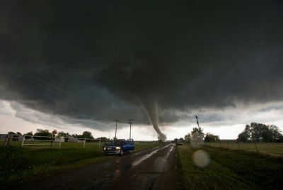
Tornado warnings were issued for Noble, Logan and Payne Counties until 2 a.m. as storms tracked through the region overnight. Large hail and damaging winds were expected overnight Sunday, with the slight possibility of isolated tornadoes if conditions presented themselves, according to the News 9 Storm Team, which monitored the system as it moved across the state.
Widespread Power Outages in Woodward
The storms left a significant mark on the electrical grid in northwestern Oklahoma. OG&E reported close to 2,500 people without power in Woodward after severe storms caused several outages overnight Sunday. The first outages were reported close to 11:22 p.m., with an estimated time of restoration close to 5 a.m. Monday morning.
The disruption extended beyond Woodward itself, with reports of approximately 400 additional people without power near Harper, Oklahoma, as the storm system continued moving through the area.
A Train Knocked Over by High Winds
Among the more dramatic incidents reported during the overnight severe weather event, high winds knocked over a train east of Woodward, underscoring the intensity of the wind gusts accompanying the storm system as it tracked across the region.
Storm Damage in Fairview
Beyond the power outages and the overturned train, storm damage was also reported in Fairview as the severe weather system continued its path through northwestern Oklahoma, contributing to a broader picture of property impacts across multiple communities affected by the overnight storms.
A Sequence of Escalating Warnings
The National Weather Service issued a series of escalating warnings throughout the evening and overnight hours as the storm system intensified and moved across the state. A Severe Thunderstorm Warning was issued until 10:15 p.m. for Woodward County, followed later by a Flood Warning issued for the Chikaskia River near Blackwell, affecting Grant and Kay Counties. Subsequently, a Severe Thunderstorm Warning was issued until midnight for Ellis, Woods, Harper, and Woodward Counties, before the tornado warnings for Noble, Logan, and Payne Counties followed in the early morning hours.
Part of a Broader, Historically Active Severe Weather Month
Monday's storms in Oklahoma arrive amid what meteorologists have already characterized as an exceptionally active stretch of severe weather across the central United States this month. June is off to an exceptionally violent, near-historic start across the United States, cementing 2026 as one of the most active severe weather years in recent memory. Data tracking preliminary severe storm logs from June 1 through June 16 reveals that the nation is experiencing its second-fastest start for damaging straight-line wind reports since comprehensive record-keeping began in 1955.
That pace of severe weather activity has been surpassed only once in recorded history during the same early-month window. This month's relentless barrage of bowing thunderstorm complexes and intense squall lines has churned out wind damage at a pace surpassed only by the legendary, hyperactive June of 2008, which logged a staggering 3,619 wind reports during the exact same 16-day opening window. If the upcoming weeks remain this highly charged, atmospheric experts believe 2026 stands a legitimate chance at challenging the all-time full-month June record of 5,554 wind reports.
A Year Already Marked by Deadly Tornado Activity in Oklahoma
Sunday and Monday's storms add to what has already been a dangerous year for severe weather across Oklahoma specifically. Earlier this year, Oklahoma experienced a high-end EF-4 tornado in April, along with a localized, multi-tornado event earlier this month on June 11. In March, a deadly outbreak in the state killed a mother and daughter in Major County when an EF2 tornado struck their vehicle near U.S. 60, while additional tornadoes touched down near Cleo Springs, Jet, Helena, and Wakita during the same multi-day event.
Continued Severe Weather Threat Across the Central U.S.
As of Monday morning, the broader threat of severe weather and flooding remained active across a wide swath of the central United States. Storms and flood threats continue to persist across the central U.S., according to weather tracking services monitoring the region, suggesting additional rounds of severe weather remained possible as the broader system continued moving through the Plains states.
What Residents Should Do
With power outages affecting thousands of residents in Woodward and Harper, and storm damage reported in multiple communities, residents in affected areas were urged to monitor official weather alerts and avoid downed power lines and debris while restoration crews worked to repair damage. Estimated restoration times for the Woodward outages were set for around 5 a.m. Monday, though officials cautioned that timelines could shift depending on the extent of damage discovered during repair efforts.
With severe weather continuing to threaten portions of the central United States and meteorologists warning that 2026 could approach historic records for storm activity by the end of the month, residents across Oklahoma and neighboring states are being urged to remain vigilant for additional rounds of severe thunderstorms, large hail, damaging winds, and the potential for further tornado development in the days ahead. Continued monitoring of National Weather Service alerts and local forecasts will remain essential as the broader weather pattern responsible for this month's unusually active severe weather continues to evolve across the region.
© Copyright 2026 IBTimes AU. All rights reserved.
- Recommended For You