Tornado Watch vs. Tornado Warning: Key Differences Explained as Severe Weather Season Intensifies
As spring severe weather season ramps up across the United States, the National Weather Service continues to emphasize the critical distinction between a **tornado watch** and a **tornado warning** — two alerts that often cause confusion but carry vastly different implications for public safety.

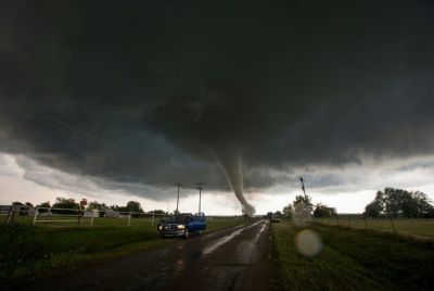
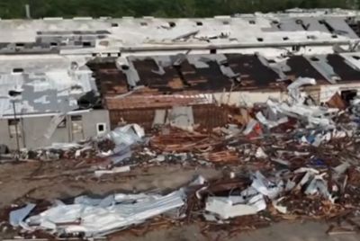
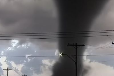
With recent devastating tornado outbreaks in the Midwest during early March 2026 leaving damage in states like Indiana and Illinois, including at least 10 fatalities reported in preliminary assessments from the first 10 days of the month, meteorologists and emergency officials are urging residents to understand these terms clearly. The difference can mean the difference between preparation and immediate life-saving action.
According to the latest guidance from the National Oceanic and Atmospheric Administration's National Weather Service, a **tornado watch** signals that conditions are favorable for the development of tornadoes in and near a designated area. Issued by the Storm Prediction Center in Norman, Oklahoma, watches cover large regions — often spanning multiple counties or even several states — and are typically announced several hours in advance, sometimes up to 4 to 8 hours or more.
A watch does not mean a tornado is occurring or imminent. Instead, it means the atmospheric ingredients — such as instability, wind shear and moisture — are in place for severe thunderstorms that could produce tornadoes, along with damaging winds of 58 mph or higher and hail of 1 inch in diameter or larger. The NWS describes it as a "be prepared" alert: Residents should review family emergency plans, check supplies like flashlights, batteries and water, identify safe shelter locations and stay tuned to weather updates or NOAA Weather Radio.
In contrast, a **tornado warning** represents an urgent "take action" directive. Issued by local National Weather Service forecast offices, warnings are triggered when a tornado has been sighted by trained spotters, law enforcement or storm chasers, or when radar strongly indicates a rotating storm with tornadic characteristics. These alerts cover much smaller areas — often the size of a city or a portion of a county — and usually last 30 to 60 minutes.
When a warning is in effect, there is imminent danger to life and property. The NWS instructs people to seek shelter immediately: Move to an interior room on the lowest floor of a sturdy building, away from windows, and cover yourself with blankets or mattresses for protection from flying debris. Those in mobile homes, vehicles or outdoors should relocate to the nearest substantial shelter. Basements or storm cellars offer the best protection, though any low-lying interior space is preferable to remaining exposed.
The NWS stresses that warnings can sometimes be issued without a preceding watch if a tornado develops suddenly, though most major events occur under watch conditions. In extreme cases involving particularly violent, long-track or densely populated threats, forecasters may escalate language to a **tornado emergency** — a rare, enhanced wording within a warning that underscores catastrophic potential and urges immediate protective action.
Recent events highlight the real-world stakes. During the March 10, 2026, outbreak across parts of the Midwest, multiple tornado warnings were issued as storms produced confirmed tornadoes, resulting in widespread damage to homes, infrastructure and communities in Indiana and Illinois. Videos and reports from the scene showed debris scattered across fields and neighborhoods, underscoring how quickly conditions can deteriorate from watch-level risk to warning-level emergency.
Experts note that public response improves dramatically when people recognize the progression: A watch prompts proactive steps like charging devices and designating roles for family members, while a warning demands instant movement to safety. Misunderstandings persist, with some interpreting a watch as time to "go look for a tornado" or a warning as merely something to monitor — dangerous misconceptions that the NWS actively combats through public education campaigns, especially during Severe Weather Awareness Weeks held in various states.
In 2026, as climate patterns continue to influence severe weather frequency and intensity, forecasters report that early-season outbreaks like the recent one align with historical norms for March and April in the central and southern Plains, extending into the Southeast and Midwest. The Storm Prediction Center's convective outlooks often include watch probabilities days in advance, giving communities extra lead time.
Safety recommendations remain consistent regardless of location. The NWS advises against seeking shelter under highway overpasses, in vehicles during warnings or near exterior walls and windows. For those with disabilities or mobility challenges, advance planning — such as identifying accessible shelters or arranging assistance — is essential.
Mobile alert systems, including Wireless Emergency Alerts sent directly to cellphones, have become a primary dissemination tool for warnings, often arriving with distinctive tones and vibrations. Residents are encouraged to enable these notifications and supplement them with battery-powered radios for continued updates during power outages.
As severe weather threats evolve, understanding the watch-warning distinction empowers individuals and communities to act decisively. The NWS mantra remains straightforward: During a watch, prepare; during a warning, act without delay.
With spring just beginning and more active periods likely ahead, officials reiterate that familiarity with these alerts saves lives. In the wake of recent tragedies, renewed focus on education could prevent future losses when the next storm system approaches.
© Copyright 2026 IBTimes AU. All rights reserved.
- Recommended For You