(VIDEO) Kansas City Tornado Update: Kansas City Braces for Severe Storms and Tornado
KANSAS CITY, Mo. — The Kansas City metropolitan area is under a heightened severe weather threat as a powerful early-spring storm system unleashes multiple rounds of thunderstorms, large hail, damaging winds and the potential for isolated tornadoes across the region. As of March 7, 2026, residents faced overnight and early-morning storms that spawned radar-indicated rotation, power outages and a tornado watch extending into the morning hours.

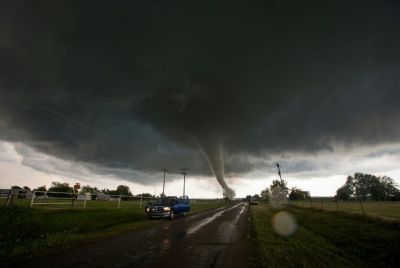
The National Weather Service in Pleasant Hill issued a tornado watch Friday evening for much of the Kansas City metro, including Johnson, Leavenworth, Wyandotte, Clay, Jackson, Platte and Miami counties in Kansas and Missouri, along with surrounding areas. The watch, which expired early Saturday, warned of possible strong tornadoes, hail up to 2-3 inches in diameter and wind gusts exceeding 75 mph. A radar-indicated tornado prompted a brief warning for parts of Jackson County, Missouri, and Johnson County, Kansas, late Friday into Saturday, though no confirmed ground touchdowns were immediately reported in the immediate metro.
Severe thunderstorm warnings blanketed the area late Friday and into Saturday, with storms capable of producing quarter- to tennis-ball-sized hail and straight-line winds up to 60-75 mph. Power outages affected thousands across the metro as lines snapped under gusty conditions and fallen trees. Residents in Grandview and other suburbs reported flooding from heavy rain earlier in the week, compounding risks.
The outbreak marks the first major severe weather event of 2026 spring season in the Plains and Midwest. The Storm Prediction Center placed parts of eastern Kansas, western Missouri—including Kansas City—and central Oklahoma under an Enhanced Risk (level 3 of 5) on Friday, forecasting numerous severe storms with a high likelihood of damaging winds, large hail and strong tornadoes (EF2 or higher, with winds 111-165 mph). Forecasters warned of "monster hail" up to hen-egg size and embedded tornadoes in squall lines.
The system began Thursday night with scattered storms in the Texas Panhandle, northwest Oklahoma and southern Kansas, producing at least seven tornado reports. A deadly EF2 tornado struck northern Oklahoma Thursday, claiming the lives of a mother and daughter in their vehicle, underscoring the dangers of nighttime twisters.
Three distinct rounds of storms targeted Kansas City on Friday:
- Round 1 (late Thursday night into Friday morning): Scattered thunderstorms with isolated severe cells, mainly producing hail and gusty winds during the morning commute.
- Round 2 (Friday afternoon/evening): Redevelopment ahead of a cold front, with higher severe potential including large hail, damaging winds and a few tornadoes.
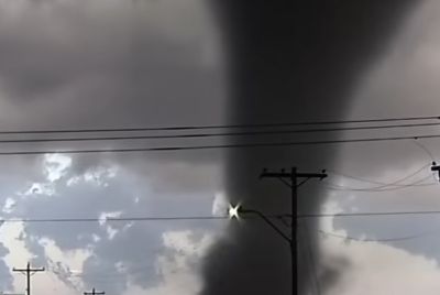
- Round 3 (late Friday night into Saturday): The strongest round along the advancing cold front, bringing the greatest risk to the metro with potential for widespread wind damage, hail and brief spin-ups.
Meteorologists noted uncertainty in exact timing and location but emphasized the cold front's role in intensifying storms after sunset. Wind shear supported brief, weaker (EF0-EF1) tornadoes embedded in lines, though isolated supercells could produce stronger ones.
The Kansas City area saw enhanced preparedness efforts amid Missouri and Kansas Severe Weather Preparedness Week (March 2-6). A planned statewide tornado drill on March 4 was canceled due to cloudy, rainy conditions that could confuse residents hearing sirens. Officials urged residents to review plans, designate safe interior rooms on the lowest floor and monitor NOAA Weather Radio, apps or local broadcasts.
No widespread structural damage or injuries were reported in the immediate Kansas City metro as of early Saturday, though scattered outages and debris posed hazards. Storms pushed eastward Saturday, shifting the severe threat to marginal risk levels across the eastern U.S., with continued hail and wind concerns.
This early March outbreak aligns with climatological patterns where severe weather ramps up in the Plains ahead of spring. Forecasters warn that climate variability could bring more frequent intense events, urging vigilance. Residents should stay weather-aware, charge devices, have backup plans and avoid flooded roads—"Turn around, don't drown."
As cleanup continues and skies clear gradually Saturday, attention turns to assessing impacts and preparing for potential follow-up systems. The National Weather Service continues monitoring, with live radar and updates available through local outlets like KMBC, KCTV5 and FOX4KC.
Kansas City's resilience in the face of volatile weather remains key, but Friday's multi-round assault served as a stark reminder of spring's unpredictable fury in Tornado Alley fringes.
© Copyright 2026 IBTimes AU. All rights reserved.
- Recommended For You