(VIDEO) Tornado Warning Pittsburgh: Tornado Warning Issued for Severe Storms In Western Pennsylvania
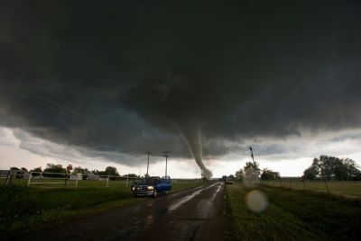
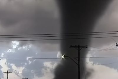
PITTSBURGH (AP) — A tornado warning was briefly in effect Wednesday afternoon for portions of Allegheny County, including parts of Pittsburgh, as a line of severe thunderstorms moved through western Pennsylvania, prompting urgent safety alerts from the National Weather Service.

The warning, issued around 1:57 p.m. EDT, targeted central Allegheny County and northeastern Washington County until 2:30 p.m. EDT. Meteorologists detected radar-indicated rotation in a severe thunderstorm over McDonald, about 8 miles northwest of Canonsburg, moving east at approximately 40 mph.
"Hazard... Tornado," the National Weather Service in Pittsburgh stated in the alert. "Source... Radar indicated rotation. Impact... Flying debris will be dangerous to those caught without shelter. Mobile homes will be damaged or destroyed. Damage to roofs, windows and vehicles will occur. Tree damage is likely."
Locations potentially affected included Pittsburgh, Mount Lebanon, Bethel Park, McKeesport, West Mifflin, Baldwin, Upper St. Clair, Scott Township, Wilkinsburg, Whitehall, Robinson Township, Munhall, Brentwood, Swissvale, Dormont and Castle Shannon.
Residents in the warned areas were urged to take immediate action: move to an interior room on the lowest floor of a well-built building, away from windows. Those outdoors, in mobile homes or vehicles were advised to seek the nearest substantial shelter and protect themselves from flying debris.
The tornado warning was part of a broader severe weather event impacting the region. A tornado watch remained in effect until 8 p.m. EDT for multiple counties in western Pennsylvania, including Allegheny, Fayette, Greene, Indiana, Somerset, Washington and Westmoreland. The watch indicated conditions favorable for severe thunderstorms capable of producing tornadoes, large hail and damaging winds.
Earlier in the afternoon, a severe thunderstorm warning covered parts of Allegheny, Beaver, Washington and Westmoreland counties until 2:15 p.m. Severe thunderstorms tracked along a line from Coraopolis to near Avella, or from Moon Township to near Avella, moving east at 60 mph. Hazards included 60 mph wind gusts, with expected damage to roofs, siding and trees. Impacted communities ranged from Pittsburgh and Penn Hills to Ross Township, McCandless Township, Moon Township, Weirton, Franklin Park, Shaler Township, Plum, North Side Pittsburgh, Hampton Township, Scott Township, Wilkinsburg, Robinson Township, New Kensington, Lower Burrell and Harrison Township.
Additional severe thunderstorm warnings followed, including one for Allegheny, Armstrong, Beaver, Indiana, Washington and Westmoreland counties, with storms moving east at 55 mph from areas near Leechburg to Pittsburgh.
The Storm Prediction Center had placed western Pennsylvania, along with eastern Ohio and the northern West Virginia panhandle, under a "slight" risk (level 2 out of 5) for severe weather. Forecasters noted increased confidence in severe storms, with potential for a few significant events featuring damaging winds as the primary threat, though isolated tornadoes remained possible.
Meteorologists described the setup as a "messy" severe weather situation, with multiple rounds of storms possible through the evening hours, potentially until 10 p.m. The region faced threats of damaging winds, hail and isolated tornadoes amid an active weather pattern contributing to outbreaks across parts of the Midwest and South.
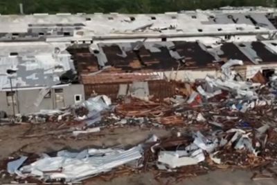
No immediate reports of confirmed tornadoes or major damage emerged from the Pittsburgh area as the warned storms passed. The National Weather Service encouraged residents to report any storm damage, including downed trees, power outages or structural impacts, via social media comments or official channels.
As the tornado warning expired around 2:30 p.m., some updates indicated cancellations for specific segments, such as those covering Pittsburgh, West Mifflin and Baldwin. However, the overarching tornado watch continued, signaling the need for vigilance through the evening.
The National Weather Service Pittsburgh office, based in Moon Township, maintained active monitoring. Interactive radar tools and wireless emergency alerts were recommended for real-time updates.
Severe weather events like Wednesday's are not uncommon in early spring across Pennsylvania, where clashing air masses can fuel thunderstorms. Residents are advised to have a plan in place: identify safe shelter locations, monitor NOAA Weather Radio or local news, and heed all warnings promptly.
Forecasters stressed that tornadoes can develop rapidly from severe thunderstorms, leaving little time for preparation. Safety guidelines include avoiding windows, not opening doors to check conditions and staying informed via official sources.
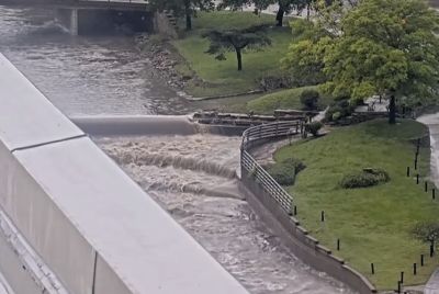
As storms moved eastward, attention shifted to potential lingering effects, such as downed power lines or localized flooding from heavy rain accompanying the thunderstorms. No widespread power outages or injuries were immediately reported in connection with the afternoon warnings.
The event unfolded amid a national severe weather outbreak, with nighttime tornado risks noted in other regions earlier in the week. In western Pennsylvania, the focus remained on wind damage and the isolated tornado threat.
Local broadcasters, including WTAE, KDKA and WPXI, provided continuous coverage, urging viewers to stay tuned for updates. Social media posts from meteorologists and news outlets amplified the alerts, with some automated safety responses emphasizing immediate sheltering.
As of late Wednesday afternoon, the primary severe weather threats appeared to ease in the immediate Pittsburgh metro area, though isolated storms could persist. Residents were encouraged to remain weather-aware, especially with the tornado watch extending into the evening.
The National Weather Service continues to urge proactive preparation during severe weather season. Resources for safety tips, including thunderstorm and tornado preparedness, are available on weather.gov.
© Copyright 2026 IBTimes AU. All rights reserved.
- Recommended For You