Heavy Snow Warnings Issued Across Multiple U.S. States as Late-Season Winter Storm Brings Hazardous Conditions
The National Weather Service has issued winter weather warnings and advisories for several states amid a persistent late-winter pattern delivering heavy snow, strong winds and hazardous travel conditions in early March 2026.

As of March 5, active alerts target areas in Alaska, Montana, Maine, New Hampshire and Oregon, where forecasters warn of significant snowfall accumulations reaching up to 11 inches in isolated spots. The system, fueled by lingering cold air despite the start of meteorological spring, has prompted concerns over slick roads, reduced visibility and potential power disruptions from wind gusts.
In Alaska, the heaviest impacts focus on southeast regions including Glacier Bay, eastern Chichof Island, Cape Fairweather to Lisianski Strait and the Juneau area. Between 4 and 10 inches of snow have fallen or are expected through midday Wednesday, with rates up to 1 inch per hour at times during peak periods. The National Weather Service office in Juneau highlighted "hazardous traveling conditions" due to the combination of heavy snow and gusty winds.
Montana faces similar threats in higher elevations and northern plains, where accumulations of several inches could complicate mountain passes and rural roadways. Maine and New Hampshire, still recovering from earlier nor'easters in February, see renewed warnings for coastal and interior areas expecting 4 to 8 inches in some locales, accompanied by winds that may produce blowing snow and near-blizzard visibility at times.
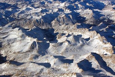
Oregon's Cascade Range and higher terrain are under alerts for heavy mountain snow, with forecasts calling for 6 to 10 inches above 4,000 feet elevation. Lower elevations may see rain transitioning to wet snow, increasing risks of slushy accumulations and icy patches.
The alerts follow a turbulent start to March, which began with an Alberta Clipper system dumping heavy snow across the Midwest and Northeast on March 1. That fast-moving storm triggered winter weather advisories from the Rockies to New England, followed by flash freeze risks as Arctic air plunged southward. Dangerous travel persisted into the following days in parts of the northern tier.
Earlier in the season, a blockbuster blizzard in late February — dubbed the "Blizzard of 2026" — paralyzed the Northeast with 2 feet or more of snow in places like Rhode Island, where records were set with nearly 38 inches in some measurements. Wind gusts topped 75 mph in spots, leading to widespread power outages, travel bans and flight cancellations affecting millions.
While that historic event has passed, residual cold and new systems have kept winter weather relevant into March. Forecasters note that La Niña influences, though weakening toward neutral conditions by late winter, have contributed to variable patterns with pockets of heavier precipitation in northern regions.
In the Northeast, a recent wintry mix of snow, sleet and freezing rain moved into Massachusetts and surrounding states on March 4-5, prompting winter advisories for parts of Essex, Middlesex, Norfolk, Suffolk, Worcester, Hampshire, Hampden and Franklin counties through Friday morning. Up to half an inch of rain mixed with ice accretion created slick conditions during evening and morning commutes, with meteorologists warning of hazardous glaze on elevated surfaces.
Travel impacts remain a primary concern nationwide. Officials urge drivers to avoid unnecessary trips, equip vehicles with winter tires or chains where required, and carry emergency kits. Power companies in affected areas have mobilized crews in anticipation of isolated outages from snow-weighted lines or wind damage.
The current pattern reflects broader seasonal trends, where March often brings transitional weather with late snow events possible even as spring approaches. Climate outlooks from NOAA indicate that while overall winter snowfall trended variable under weak La Niña conditions, northern and mountainous regions continue to see episodic heavy events.
Residents in warned areas are advised to monitor updates from local National Weather Service offices, as conditions can change rapidly with shifting storm tracks. In Alaska and the Pacific Northwest, additional moisture from Pacific systems could prolong accumulations, while East Coast locations watch for any reinforcing cold air that might extend wintry precipitation.
As the week progresses, attention shifts toward potential severe thunderstorms in the central and southern Plains, signaling a transition to spring-like threats. However, for now, heavy snow warnings underscore that winter's grip lingers in parts of the country.
The alerts highlight the importance of preparedness amid unpredictable late-season weather. Communities from the Pacific Northwest to New England continue clearing roads and assessing damage from prior storms while bracing for the latest round of wintry conditions.
© Copyright 2026 IBTimes AU. All rights reserved.
- Recommended For You