(VIDEO) Tornado Warnings Triggered Across Southeast Louisiana as Severe Storms Batter Region
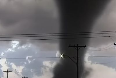
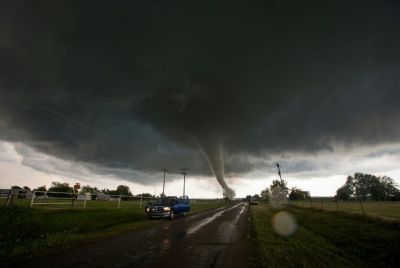
NEW ORLEANS — Tornado warnings swept across southeast Louisiana on Saturday morning, April 25, 2026, as a line of potent thunderstorms unleashed damaging winds, possible waterspouts and radar-indicated rotation, disrupting communities from the West Bank to the Northshore and prompting urgent safety alerts.

The National Weather Service in New Orleans issued multiple tornado warnings before noon as storms tracked southeast at 35-40 mph. One warning covered northwestern Plaquemines Parish, northeastern Jefferson Parish, southwestern Orleans Parish and west-central St. Bernard Parish until 12:45 p.m. CDT. Another targeted areas near the West Bank, with strong winds nearing 70 mph reported over parts of Jefferson Parish, including near TPC Louisiana.
Meteorologists tracked rotation in thunderstorms moving over the region, with one cell crossing Lapalco Boulevard on the West Bank. The Zurich Classic golf tournament at TPC Louisiana faced delays due to the severe weather. Special marine warnings also went into effect for Lake Pontchartrain, Lake Maurepas, Lake Borgne and coastal waters, citing waterspouts and gusts up to 40 knots that could endanger boaters.
No immediate reports of major structural damage or injuries surfaced in the early hours, but officials urged residents to take cover in interior rooms away from windows. Emergency management teams monitored the situation closely as storms continued into southern Mississippi.
The activity stems from an active spring weather pattern across the southern Plains and Mississippi Valley. Friday night into Saturday morning brought a marginal to slight risk of severe weather, with damaging winds as the primary threat, isolated large hail possible and a low-end tornado risk. Storms developed northwest of the area and marched southeast, tapping into instability overnight.
Forecasters noted medium confidence in how far the overnight complex would hold together, but it delivered gusty conditions and lightning across the Northshore and metro New Orleans between 2 a.m. and 6 a.m. before intensifying Saturday morning. A separate slight risk (level 2 of 5) looms for Sunday afternoon and night, mainly north of Interstate 10, with wind damage as the main concern.
Residents woke to thunder, heavy downpours and strong winds. In Baton Rouge, strong-to-severe storms moved in around 4:30 a.m., bringing frequent lightning. Similar reports came from Hammond, Slidell and Houma, where observations showed gusts, rain and mist.
Power outages affected thousands in prior recent severe events, though specific figures for Saturday remained unavailable early in the day. Local utilities prepared crews for potential restoration work.
This outbreak fits a broader pattern of severe weather this month. April 2026 has already seen multiple rounds of storms across Louisiana, with confirmed tornadoes in previous events. The National Weather Service has documented numerous tornado reports statewide in recent weeks, underscoring the heightened spring risk in the region.
Emergency officials reminded the public of safety protocols. "If you hear a tornado warning, take shelter immediately," said a National Weather Service spokesperson. "Mobile homes and vehicles are especially vulnerable."
For boaters, marine warnings highlighted sudden higher waves and the risk of waterspouts capsizing vessels. Life jackets were strongly recommended, with advice to seek safe harbor.
The storms follow a week of fluctuating threats. On Friday, severe potential included hail up to 1 inch and damaging winds exceeding 60 mph in some areas. While the overnight system weakened somewhat before reaching deeper into southeast Louisiana, morning intensification caught some off guard.
Meteorologist Zack Fradella with FOX 8 noted strong winds despite modest rotation on radar in one West Bank warning. Live coverage from stations like WWL-TV and WDSU tracked the cells in real time, updating viewers on warning expirations and new issuances.
As the line pushed east, warnings shifted toward St. Tammany Parish and into Mississippi. Forecasters expected gradual weakening through the afternoon, but additional scattered storms could pop up later Saturday.
Looking ahead, the weekend remains unsettled. Another round is possible Sunday, though tornado chances appear lower. Highs will climb into the mid-80s with muggy conditions fueling instability.
Louisiana's geography — flat terrain, proximity to the Gulf and abundant moisture — makes it prone to such outbreaks. Tornadoes, while not always strong, can develop quickly in embedded supercells or quasi-linear convective systems like the one observed Saturday.
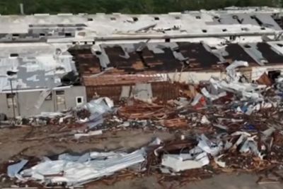
Communities in southeast Louisiana have faced repeated alerts this spring. Earlier in April, tornado warnings hit parishes including Washington, with radar confirming rotation near Bogalusa. Confirmed touchdowns have occurred in multiple events, damaging homes and infrastructure.
Residents are advised to review their severe weather plans. Have a designated safe spot, a weather radio or app with alerts, and an emergency kit. For those in flood-prone areas, monitor for heavy rain that could cause localized ponding despite the main threat being wind and rotation.
The Storm Prediction Center continues to monitor the broader pattern, with active weather expected through the weekend into early next week. While no major outbreak like those farther north materialized, the repeated warnings highlight the need for vigilance.
As skies clear later Saturday, temperatures will rebound, but the memory of morning sirens and swirling clouds will linger. Southeast Louisiana dodged significant impacts this time, yet the event serves as a reminder that tornado season demands respect and preparation.
Local officials reported no confirmed tornado touchdowns by mid-morning, but surveys will follow for any damage. Storm spotters and emergency responders remained active, documenting wind gusts and hail where reported.
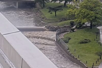
In New Orleans proper, rain and lightning affected morning commutes, with some areas seeing reduced visibility. Drivers were urged to slow down and avoid flooded roads.
This story will be updated as more information becomes available, including any damage assessments or additional warnings. Stay tuned to local media and the National Weather Service for the latest.
© Copyright 2026 IBTimes AU. All rights reserved.
- Recommended For You