

(VIDEO) Gulf Disturbance Invest 97L Could Become Tropical Storm Edouard Before Reaching Texas Coast
Invest 97L could develop into Tropical Storm Edouard, bringing heavy rain to Texas and Louisiana.
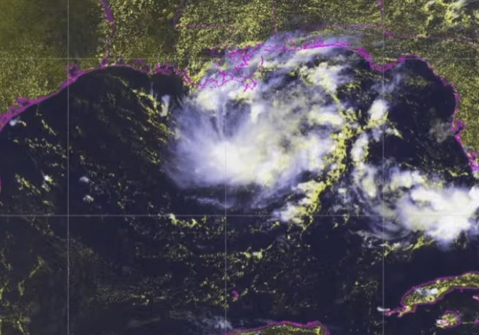
MIAMI — The National Hurricane Center is monitoring two areas of potential tropical development in the Atlantic basin, with a disturbance in the northern Gulf carrying increasingly high odds of strengthening into a short-lived tropical depression or tropical storm before reaching the Texas or Louisiana coast as soon as Monday night.
The system, designated Invest 97L, was located roughly 100 to 125 miles south of the southeastern Louisiana coast as of Monday morning, according to the National Hurricane Center. As of the agency's latest advisory, the disturbance carried a 70% chance of development over both the next 48 hours and the next seven days, an increase from the 30% to 50% odds forecasters had assigned the system over the weekend as it became better organized. An Air Force Reserve reconnaissance aircraft, commonly known as a hurricane hunter, was scheduled to investigate the low-pressure area Monday morning to gather more detailed data on its structure.
Forecasters say the disturbance is expected to drift slowly west-northwest across the northern Gulf before potentially strengthening into a short-lived tropical depression or tropical storm as it approaches the upper Texas or southwestern Louisiana coast late Monday or early Tuesday. If the system's maximum sustained winds reach 39 mph, it would be named Tropical Storm Edouard, the fifth named storm of the 2026 Atlantic hurricane season. The National Hurricane Center has said tropical storm watches or warnings could be issued for portions of the Gulf Coast later Monday as the system continues to organize.
Regardless of whether the disturbance officially strengthens into a named storm, forecasters say its primary threat will be heavy rainfall rather than strong winds. The National Hurricane Center said the system is expected to bring locally heavy rain to portions of the upper Texas and southwestern Louisiana coasts over the coming days, with rainfall totals of up to 2 inches expected in some areas and higher localized amounts possible. Southern Louisiana has been placed under a marginal risk for heavy rainfall, raising the potential for flash flooding, particularly given recent dry conditions in the region. Forecasters covering the Houston area have said the system could bring an uptick in showers and storms by Tuesday and Wednesday as it moves inland, with the potential for rainfall totals to climb further depending on how the system tracks once it makes landfall.
Separately, the National Hurricane Center is also tracking the remnants of former Tropical Storm Dolly, which are producing showers and thunderstorms stretching from Hispaniola eastward to the northern Leeward Islands. That system is moving west to west-northwest at roughly 20 to 25 mph, and forecasters say strong upper-level winds are expected to prevent redevelopment over the next couple of days. The National Hurricane Center has given Dolly's remnants a near-zero chance of redevelopment over the next 48 hours and just a 20% chance over the next seven days. Even without redeveloping into a formal tropical system, forecasters say the moisture associated with Dolly's remnants could reinforce an already wet pattern across South Florida later this week as the disturbance approaches the southern Bahamas or the Florida Straits. Should either the Gulf system or Dolly's remnants develop into a named storm, the next name after Edouard on this year's Atlantic storm list would be Fay.
The Atlantic hurricane season is now moving into its historical peak period, which arrives around Sept. 10 and spans the stretch from mid-August through mid-October, when ocean temperatures are typically at their warmest and atmospheric conditions are often more conducive to tropical development. So far this season, the Atlantic has produced four named storms, Arthur, Bertha, Cristobal and Dolly, but no hurricanes. By comparison, the climatological average season has typically produced its sixth named storm and first hurricane, generally forming around Aug. 11, by this point on the calendar, putting the 2026 season somewhat behind its typical pace in both named storm activity and hurricane formation.
Forecasters have cautioned that a slower-than-average start to the season does not determine how active the remainder of it will be. With the Atlantic entering its peak window for tropical activity, meteorologists say conditions can shift quickly, and it takes only one significant landfalling storm to make a season consequential regardless of how quiet its earlier months may have been. Residents along the Gulf Coast, particularly in southeast Texas and southwestern Louisiana, are being urged to monitor forecast updates closely in the coming days as Invest 97L continues its approach toward the coastline.
© Copyright 2026 IBTimes AU. All rights reserved.