(VIDEO) Antarctic Cold Front to Bring Hail, Snow and Damaging Winds to Four Australian States Starting
Low-pressure system to bring icy conditions, hail, and blizzard-like weather to multiple states
SYDNEY — Millions of Australians across the country's southeast are being warned to brace for a blast of icy weather in the coming days, as a powerful low-pressure system currently sitting near Antarctica tracks toward the mainland, threatening to bring hail, snow, damaging winds and heavy rain to at least four states.
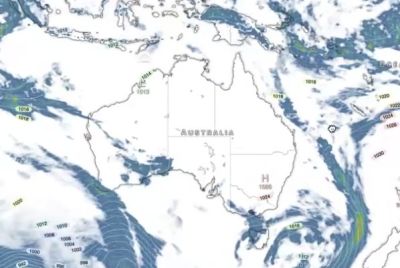
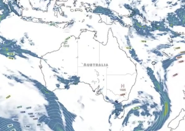
According to weather service Weatherzone, the low-pressure system is expected to travel more than 4,000 kilometers between Wednesday and Saturday, passing to the south of Australia over the weekend as it drags a large mass of polar air across the Southern Ocean toward the mainland. The severe weather is forecast to affect Victoria, Tasmania, New South Wales and southern Queensland, according to the outlook.
A Two-Stage Weather Event
Forecasters say the system will unfold in two distinct phases. Wind and rain are expected to increase across southeastern Australia from Saturday into Sunday, as northerly winds strengthen ahead of the approaching cold front. That initial pre-frontal air is expected to remain relatively warm, meaning most of the precipitation during this early stage will fall as rain rather than snow, with the exception of higher terrain in the Alps.
The more severe, bitterly cold conditions are expected to arrive from late Sunday into Monday, as the cold air mass spreads across New South Wales, Victoria, southern Queensland and the Australian Capital Territory, before reaching Tasmania on Monday. During this stage, forecasters are warning of blustery winds, rain, hail, thunderstorms and snow across southeastern Australia, conditions that could include damaging to destructive wind gusts and flooding rain.
Destructive Winds and Blizzard Conditions Possible
Damaging wind gusts are considered likely to develop across parts of Victoria, New South Wales and the ACT, with forecasters saying those conditions may also extend into Tasmania. In the highest terrain, particularly across the Australian Alps, the system is expected to bring destructive wind gusts alongside blizzard conditions. Rain is forecast to be widespread across the country's southeastern states on Sunday and Monday, with the heaviest rainfall totals expected along the ranges of central and northeastern Victoria and southern New South Wales.
Bureau of Meteorology Tracks the System's Path
David Crock, a meteorologist with the Bureau of Meteorology, said a cloud band was expected to continue streaming over inland Western Australia and parts of South Australia on Friday, ahead of the more severe conditions forecast for the weekend. Describing what would follow, Crock said a strong cold front would reach southwest Western Australia later Friday before continuing across South Australia over the course of the weekend. He added that elsewhere in the country, the dry season remains in full swing across northern Australia, with only a few light showers expected along parts of the Queensland coast.
Crock also noted that cloud and showers are likely to persist Friday around Australia's southern states, as the broader system continues developing ahead of the more intense wintry conditions expected to arrive over the following days.
A Boost for Ski Resorts
While the system is expected to bring disruptive and potentially hazardous conditions to populated areas, it is also likely to deliver a significant benefit to Australia's alpine ski resorts. Forecasters say it is extremely likely that the natural snow depth at Spencers Creek, a key benchmark measurement site in the Snowy Mountains, will be well over a meter by the same time next week, with the majority of lifts across the country's ski resorts expected to be operating as a result of the fresh snowfall. Thredbo, one of the region's largest ski resorts, became the first Australian ski area to operate at full capacity in 2026 earlier this week, with all 15 of its lifts running.
A Pattern of Severe Winter Weather
The approaching system fits within a broader pattern of significant cold outbreaks that have periodically struck southeastern Australia during winter months in recent years, driven by low-pressure systems tracking north from the Antarctic region. Similar events in past years have brought rare snowfall to lower-elevation areas not typically accustomed to significant winter weather, along with widespread disruption including road closures, flight cancellations and, in some cases, livestock losses on farms caught in the path of the coldest conditions.
Authorities Urge Caution
With the more severe phase of the system expected to bring a combination of flooding rain, damaging winds and hazardous alpine conditions, residents across the affected states are being urged to stay updated on official weather warnings as the system continues to develop over the coming days. Authorities have reiterated standard guidance that anyone facing a life-threatening situation as a result of the severe weather should contact emergency services immediately.
What to Expect in Each State
For Victoria, New South Wales and the ACT, the greatest risks are expected to center on damaging wind gusts, heavy rainfall and potential flooding, particularly across higher terrain and along the ranges of central and northeastern Victoria and southern New South Wales. Tasmania is expected to see the cold front's most intense conditions arrive slightly later, on Monday, with blizzard conditions possible in elevated alpine areas. Southern Queensland is also included in the areas expected to experience the cold air mass, extending the reach of the wintry system further north than is typical for this type of weather event.
With the low-pressure system still tracking toward the Australian mainland as of Thursday, forecasters are continuing to refine their projections for exact rainfall totals, wind speeds and snowfall accumulations as the weekend approaches. Given the system's scale and the multiple hazards it is expected to bring, including hail, thunderstorms, flooding rain and potentially blizzard conditions in alpine regions, authorities across the affected states are likely to continue issuing updated warnings and advisories in the lead-up to the system's peak impact late Sunday and into Monday.
© Copyright 2026 IBTimes AU. All rights reserved.
- Recommended For You