

Thick Wildfire Smoke Chokes Nation's Capital and Mid-Atlantic as Severe Storms Threaten Region Saturday
Dense smoke from Canadian wildfires combines with severe thunderstorms, impacting air quality across the Mid-Atlantic region.
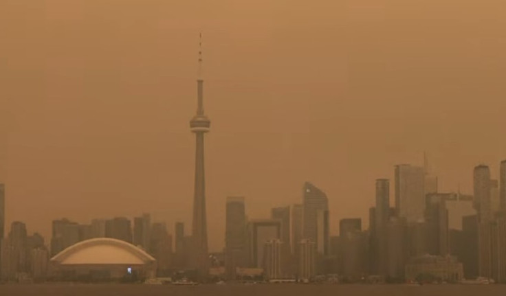
Dense wildfire smoke continued blanketing the Mid-Atlantic region early Saturday, pushing Washington, D.C., to the brink of becoming the world's most polluted major city, as forecasters warned the smoky conditions would soon collide with a separate threat of severe thunderstorms moving through the region.
Air quality readings in Washington registered at 175 between 4 and 5 a.m. Saturday, placing the city in the unhealthy to very unhealthy range for the 30th consecutive hour. As of 5 a.m., the nation's capital ranked as the second most polluted major city in the world, trailing only Toronto, according to tracking data cited by meteorologist Ben Noll.
The smoke originated from massive wildfires burning across Canada, which have spread across large portions of the United States in recent days. Forecasters expected the dense smoke to linger across the Mid-Atlantic through Saturday morning before gradually clearing during the afternoon, as southerly winds ahead of an approaching storm system began pushing the smoke back toward the Northeast and New England. Cities including Philadelphia, New York and Pittsburgh all reported unhealthy or very unhealthy air quality conditions early Saturday, with forecasters projecting the smoke would reach Boston by late morning.
Complicating the situation further, strong to severe thunderstorms are expected to develop across the region beginning Saturday afternoon. The National Oceanic and Atmospheric Administration's Storm Prediction Center issued an enhanced risk rating, a Level 3 out of 5, covering a stretch of the country that includes Buffalo, Cleveland, Washington, Philadelphia and New York. While damaging winds represent the primary threat from the approaching storms, forecasters also flagged some potential for tornadoes within the risk area.
The combination of smoke and severe weather is expected to create what forecasters described as a double dose of hazardous conditions. Rainfall can initially intensify the smell of wildfire smoke by dragging smoky air down from higher levels of the atmosphere toward the ground, and can also leave a sooty residue coating cars, windows and other outdoor surfaces. Once steadier rain develops, however, it typically begins washing smoke particles out of the air entirely, offering eventual relief even as the storms themselves bring their own risks.
By Saturday night, forecasters expect much of the current smoke plume to have cleared out of the eastern United States, though new plumes are not expected to be far behind. A separate batch of smoke from the same Canadian fires, currently drifting toward Michigan's Upper Peninsula and northern Wisconsin on Saturday, is forecast to reach Chicago and Detroit sometime between Saturday night and Sunday. That smoke is projected to continue drifting eastward into Sunday, though near-ground concentrations are expected to remain relatively low along the corridor stretching from Washington to New York.
That includes East Rutherford, New Jersey, where the World Cup final is scheduled to kick off Sunday at 3 p.m. Forecasters currently expect largely dry conditions in the area for the match, with smoke concentrations near the ground anticipated to stay comparatively low despite the broader regional smoke event still unfolding through the weekend.
Looking further ahead, changing wind patterns and additional stormy weather expected early next week could help keep the worst of the smoke away from the eastern United States. Several rounds of rain are forecast across the primary wildfire zone in western Ontario in the coming days, a development that should help reduce smoke concentrations at the source and potentially limit the intensity of future smoke plumes reaching the U.S. compared with what the region has experienced this week. Even so, forecasters noted that portions of the current smoke plume may continue drifting as far as Greenland, Iceland and the Azores through early next week, underscoring just how widely this particular smoke event has spread.
The connection between this wildfire season and the broader effects of climate change has drawn attention from researchers tracking Canada's fire activity. A wildfire analysis posted Friday by climate scientist Zeke Hausfather found that while lightning strikes are responsible for the majority of Canada's burned forest area, accounting for roughly 71% of the area burned between 1990 and 2023, surges in Canadian wildfire activity have tracked closely alongside rising temperatures.
Hausfather explained that warming plays a direct role in fire risk because warmer air pulls more moisture out of vegetation, drying out trees and grasses and making it easier for fires to both ignite and spread rapidly once started. He noted that the same fuel-drying dynamic has also been linked to a doubling of forest area burned across the western United States. "The biggest fire years are almost universally hotter and drier," Hausfather wrote.
Hausfather also addressed the role of fire fuel management strategies, commonly known as prescribed burns, in mitigating wildfire risk. While he said such strategies hold real value in areas surrounding populated communities, he argued they offer little practical benefit across the vast, remote boreal forests where much of Canada's current wildfire activity is concentrated, since those forests have largely never been logged, thinned or actively managed, and instead experience infrequent but high-intensity fires that occur in natural cycles. "You cannot have a fuel-buildup from forest mismanagement in a forest you were never managing," he said.
Despite the severity of the smoke's impact on air quality across North America this summer, Hausfather noted that this year's Canadian fire season currently appears unlikely to surpass the record set in 2023 for total land area burned. Even so, he emphasized that the season has still produced a serious impact on air pollution across the continent, largely because of how weather patterns have directed the smoke toward densely populated areas. "While overall area burned is the climate-linked trend, who breathes the smoke on a given week in July is mostly driven by the weather," Hausfather said.
With additional smoke plumes expected to continue drifting into the U.S. from Canada's ongoing fires in the days ahead, meteorologists said they will continue monitoring both the wildfire activity itself and the shifting weather patterns that determine which parts of the country bear the brunt of the resulting smoke on any given day.
© Copyright 2026 IBTimes AU. All rights reserved.