Elcho Island, Gapuwiyak, Ramingining And Milingimbi Still In Danger; Cyclone Lam Is Downgraded To Category Two Storm
Cyclone Lam lashed Northern Territory's top end. However, it has now been downgraded to a category two storm.
The storm is presently impacting inland areas of central Arnhem Land. The storm was around 135 km southwest of Galiwinju and 85 km south southwest of Milingimbi after 10 a.m. local time. It is expected that the cyclone will continue to move toward southwesterly direction. However, it will move at about 14 km/h and is expected to weaken further later today while it moves inland over Arnhem Land.
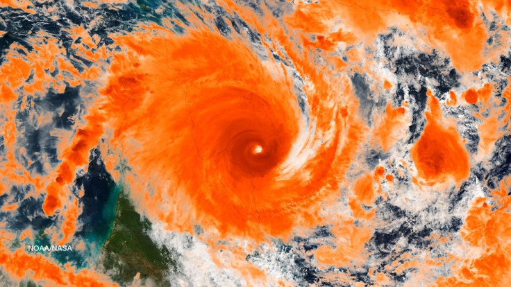
Sky News reports that the centre of the cyclone has crossed the mainland coast between Milingimbi and Elcho Island at around 2 a.m. There are no reports of anyone getting injured due to the cyclone. However, there are fence damage and tree damage. The sky is getting cleared and the rain is easing. On the other hand, trees fell on the roofs even though there were no major damages. Power lines are still down but the community can still have phone lines open. Water facilities are also available still now.
There are warnings of very dangerous storm tides for coastal residents between Nhulunbuy and Milingimbi. Cyclone Lam was earlier upgraded to a category four storm as it came at 260 km/h on Thursday night. It was around 20 km west-northwest of Galiwinku on Elcho Island. The storm is expected to maintain its intensity when it makes landfall between Milingimbi and Elcho Island at around 4am (CST) on Friday.
Lam is expected to cross the coast slowly and get weaken on Friday while moving over Amhem Land. "The very destructive core of severe Tropical Cyclone Lam is continuing to track southwest and is now impacting the coast near Elcho Island," the Bureau of Meteorology said, "Conditions at Elcho Island, Gapuwiyak, Ramingining and Milingimbi are at a dangerous level - remain in shelter now."
The 230 km/h wind gusts will continue over the mainland coast near Elcho Island and the southern Wessel Islands. There may be flooding due to heavy rain in low-lying areas in the northeast Top End on Friday. More than 400 Goulburn Island residents were moved to safety in Darwin on Thursday.
Contact the writer: s.mukhopadhyay@IBTimes.com.au
- MOST POPULAR IN News