60-million-tonne ice avalanche hits Canada’s Yukon Territory
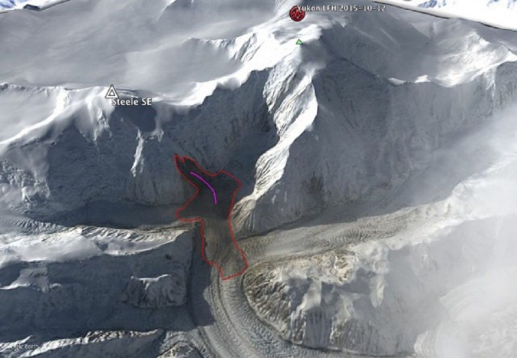
An enormous landslide happened on Oct 12 at the southeast flank of Mount Steele in the Canadian province of Yukon Territory. Fortunately, the estimated 60 million tons of ice with rocks that cascaded occurred in an unpopulated and remote area.
Gizmondo reports that the avalanche was so strong that it was detected by Goram Ekstrom and Colin Stark, experts at Columbia University, with the institution’s global seismic network made up of more than 150 stations which makes available free, real-time data using the IRIS DMC. Landsat 8 satellite images confirmed the landslide which showed displacement of a big chunk of rock and ice from Steele’s mountainside.
The incident was swift, it only happened over 110 seconds with a peak velocity of 220 kilometres per hour. Experts estimate that the 60 million tonnes of avalanche was equivalent to 700 aircraft carriers or 24 million cubic metres in terms of volume, according to the American Geophysical Union’s Landslide Blog.
Stark and Ekstrom state that the crown of the landslide is at an elevation of 3,350 metres. Its total vertical distance is estimated at 2,200 metres to the toe.
Mount Steele, according to Bivouac.com, is the fifth highest mountain in Canada. It is located at the head of Steele Glacier that flows into the Donjek River. The peak was named after Sir Sam Steele, a North-West Mounted Police officer who was in charge over Yukon during the Klondike Gold Rush.
Contact the writer at feedback@ibtimes.com.au or tell us what you think below
- MOST POPULAR IN Science