

Scientists Develop System To Locate Lost Ships and Planes
A new concept using existing satellite technology could aid in the search for lost ships or aircrafts on Earth’s oceans. Dr Nigel Bannister, a space scientist from University of Leicester, collaborated with the New Zealand Defence Technology Agency and DMC International Imaging in conducting experiments on the use of satellite imagery for this intent. Pilot study on the concept mentioned 54 satellites with 85 sensors, which could be maximised to gather images of the seas and inland waters.
Satellite imagery, which has various applications, can also be used to monitor routes taken by ships or planes more accurately. These information can be used to track missing vessels within a specified area and make it easier for rescue operations to hasten the search. The scientists were able to observe the data taken regularly using satellite technology. They believe that identifying the possible location of a missing vessel would limit the search area to a hundred square miles and make rescue efforts more effective.
Bannister said that tracking maritime traffic in small vessels is a major concern at present, and this system could make it easier to monitor vessel movements on land and water. He also clarifies that this system is not intended for real time surveillance but rather a maximisation of current technology and the time a satellite passes over certain areas of the sea. Recorded images will help search operations determine a missing vessel’s last detected position. Detailed information on this study was published in the International Journal of Remote Sensing.
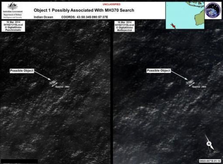
“The University of Leicester’s research is a watershed event encouraging international satellite owners and operators to collect and share open ocean imagery for the common good of enhancing safety of life at sea. The case of the missing Malaysian flight MH370 demonstrates how easy it is to lose a large object, even with today’s technology,” stated David Neyland, a former Director of the US Navy Office of Naval Research-Global. The researchers are currently testing the system to detect vessels using imagery provided by NigeriaSat 2 and UK-DMC2 satellites by DMC International Imaging and assistance from the New Zealand Defence Technology Agency.
To send feedback about the content, email: j.panganiban@ibtimes.com.au


