

Cyclone Christine Intensifies to Category 3 Storm, Western Australia Prepares for 'Threat to Lives, Homes'
Iron ore shipments from Northern Australia are placed on hold following the cyclone forecast in Western Australia. Tropical Cyclone Christine is seen as threat to towns and production of oil and gas.
Tropical Cyclone Christine has been reclassified from a Category 2 to a Category 3 storm as it picked up speed overnight. The cyclone is predicted to make landfall between Karratha and Port Hedland on the Pilbara coast. Affected areas should expect winds of around 200 kilometres per hour near the eye of the storm.
Port Hedland is the biggest ore-export terminal in the world and is located 1,300 km north of Perth. BHP Billiton stated it is getting ready for severe weather as the company expects its operations in the region to be affected.
According to IG Markets strategist Evan Lucas, the worst-case scenario would be the cyclone hitting the pits and rail networks. Western Australia Department of Fire and Emergency Services issued a statement warning residents of a "possible threat to lives and homes."
The possible threat led BHP to suspend port and rail operations in Port Hedland, according to BHP spokesperson Fiona Hadley. In an email statement, Ms Hadley said preparations are underway across company sites.
Moving closer to WA coast
Cyclone Christine is moving closer to Western Australia's coast, according to the latest reports of authorities. The tropical cyclone was spotted 290 kilometres north-north-east of Port Hedland around 8pm on Dec. 29. The Bureau of Meteorology reported that Cyclone Christine is heading towards Pilbara coast at 14 kilometres per hour.
The cyclone is picking up speed since the weather bureau had tracked it moving at 10 kilometres per hour earlier in the day. The bureau has warned of Tropical Cyclone's increasing strength as it moves closer to the coast.
Australia's weather bureau has issued cyclone warnings for coastal areas on the storm's path. Cyclone warnings are in place from Cape Leveque to Exmouth including Port Hedland, Broome, Onslow and Karratha.
Cyclone Christine is expected to bring heavy rain with winds of up to 100 km/hour as it moves between Broome and Port Hedland. It will pass Karratha and Onslow by Dec. 30.
The weather bureau expects the storm to gather strength as it crosses the coast and possibly turn into a severe tropical cyclone. Authorities believe this will happen most likely between Karratha and Port Hedland.
When the cyclone becomes severe, it could cause "very destructive" gales, heavy rain and winds of up to 165 km/hour or in excess of 200 km/hour. Australians living in coastal communities between Pardoo and Mardie are warned to be ready for the storm.
-

Taiwan President Takes Office Under Close Scrutiny
-
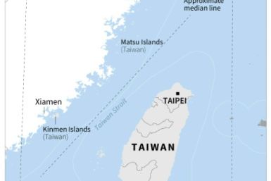
Taiwan's Lai To Bolster 'Porcupine' Defence Against China Threat
-

'Hindu Nation': Religion Trumps Caste In India Vote
-

Demirtas: Erdogan's Kurdish Nemesis Condemned To Prison
-

RBA Unlikely To Raise Interest Rates As Australia's Unemployment Rate Hits 4.1%


