NASA: 'Merging Tsunami' Increased Massive Destruction in Japan
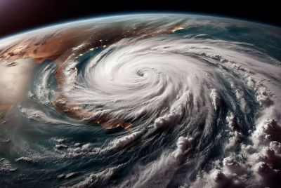
The earthquake that hit Japan on March 11 triggered the long-hypothesized "merging tsunami," researchers said, noting that data from NASA and European radar satellites captured at least two wave fronts that doubled the disaster's intensity.
According to NASA and Ohio State University researchers, the tsunami generated by the Tohoku-Oki quake centered off northeastern Japan doubled in intensity over rugged ocean ridges, which amplified its destructive power at landfall.
The satellites captured at least two wave fronts that merged to form a single, double-height wave that was capable of traveling long distances without losing power, thus causing massive destruction when it hit Japan.
Research scientist Y. Tony Song of NASA's Jet Propulsion Laboratory in Pasadena, Calif., and professor C.K. Shum of The Ohio State University in Columbus discussed the data and simulations that enabled them to piece the story together.
"It was a one in 10 million chance that we were able to observe this double wave with satellites," Song said, adding that researchers have long suspected that such "merging tsunamis" might have been responsible for the 1960 Chilean tsunami that killed about 200 people in Japan and Hawaii, but nobody had definitively observed a merging tsunami until March.
The NASA-Centre National d'Etudes Spaciales Jason-1, the NASA-European Jason-2 and the European Space Agency's EnviSAT satellites passed over the tsunami on March 11 and all three carry radar altimeters, which measure sea level changes to an accuracy of a few centimeters. The satellites crossed the tsunami at different locations, measuring the wave fronts as they occurred.
The researchers explained that ridges and undersea mountain chains on the ocean floor could have deflected parts of the initial tsunami wave away from each other and formed independent jets that created its own wave front and shot off in different directions. This study suggests scientists may be able to create maps that take into account all undersea topography, even sub-sea ridges and mountains far from shore.
"We can use what we learned to make better forecasts of tsunami danger in specific coastal regions anywhere in the world, depending on the location and the mechanism of an undersea quake," Shum said.
The research team was able to verify the satellite data through model simulations based on independent data, including GPS data from Japan and buoy data from the National Oceanic and Atmospheric Administration's Deep Ocean Assessment and Reporting of Tsunamis program.
"Tools based on this research could help officials forecast the potential for tsunami jets to merge," Song said. "This, in turn, could lead to more accurate coastal tsunami hazard maps to protect communities and critical infrastructure."
- MOST POPULAR IN Science