

MH370: ATSB Releases Fact Sheet on Search for the Missing Plane
Australia continues to lead the search for the missing Malaysia Airlines flight MH370 since late April, following the request from the Malaysian Government.
It has been more than 11 days and the Australian Transport Safety Bureau recognised the magnitude of the responsibility at hand.
"The complexities surrounding the search cannot be understated. It involves vast areas of the Indian Ocean with only limited known data and aircraft flight information. While it is impossible to determine with certainty where the aircraft may have entered the water, all the available data indicates a highly probable search area close to a long but narrow arc of the southern Indian Ocean," the ATSB wrote in its Web site.
The bureau released fact sheets on three significant aspects - considerations on defining the search, mapping the ocean floor through Bathymetric survey and the intensified underwater search for MH370 - that shed light to the direction their taking in search for the missing plane.
1. Considerations on defining the search:
- The aircraft departed Kuala Lumpur at 1641 UTC
- The final automatically transmitted position from the aircraft occurred at 17:07 UTC
- No radio communications were received from the crew after 17:19 UTC
- The final ATC (secondary) radar fix occurred at 17:22 UTC
- At 17:25 UTC the aircraft deviated from the planned flight route
- The final primary radar fix occurred at 18:22 UTC
- The satellite communications log indicated the aircraft continued to fly for another 6 hours
- No confirmed eye-witness reports were received
- The search in the Australian search and rescue zone commenced on 18 March (10 days after the aircraft went missing)
With these considerations, the search area for MH370 has remained very large and complex. Hence, the bureau determined the search area utilising all data found through ACARS and radar data, Satellite communications (SATCOM) data, Burst Timing Offset (BTO), Burst Frequency Offset (BFO), Final handshake message at 00:19 (7th arc), Aircraft Performance Calculations, Hydrophones, Air Routes and the Shape of the search area.
2. Mapping the ocean floor through Bathymetric survey
The bathymetric survey will map out the underwater search zone, detailing the contours, depths and hardness of the ocean floor through chart. However, the survey is estimated to take around three months, excluding unfavourable weather conditions and other unforseen factors.
"The underwater search will begin when we have enough data from the bathymetric survey to start searching. This means that the underwater search will begin while the survey is still being completed," ATSB wrote.
3. The intensified underwater search for MH370
The intensified underwater search is expected to take up to 12 months to explore the search area covering up to 60,000 square kilometres. To explore the underwater search area, the ATSB will use data gathered from the bathymetric survey to be conducted.
To make the intensified underwater search a success, a towed sonar, an autonomous underwater vehicle with mounted sonar, and an optical imaging equipment with sufficient resolution to identify the aircraft or a debris field from the aircraft will be used.
-

Tesla CEO Musk Meets China's Number Two Official In Beijing
-

Pope Holds Mass In Venice's St Mark's, First Trip In Months
-

Schools Closed, Warnings Issued As Asia Swelters In Extreme Heatwave
-
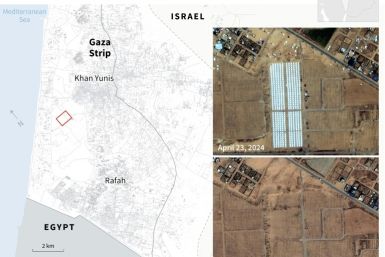
Push For Truce Ramps Up As Israel Pummels Gaza
-

Host Saudi Warns Of Economic Fallout From Gaza War At Global Summit


